Chur- Arosa
The Chur-Arosa branch of the Rhaetian Railways (Rh B) links the town of Chur with the mountain resort of Arosa. It has to overcome a height difference of 1150m in a distance of 25 km, and most of the route clings perilously to the side of a steep valley, with fabulous views. The most famous spot on the line is Langwies, where it crosses the valley on a spectacular concrete arch viaduct.
This is a very interesting project to model in Rail3D 2kd — it includes a section of “tramway” through the streets of Chur, demanding terrain, there are opportunities for a few interesting custom scenery objects, and operations are relatively simple so there’s plenty of scope for tinkering without messing everything up…
One of the most interesting aspects of this project for me has been the opportunity to play with the various terrain features of Rail3D 2kd as they have developed over the last couple of years.
Previous version
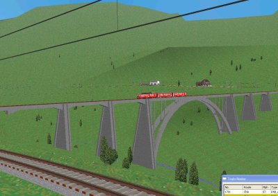
srtm terrain
The screenshots above were made with the first versions of the layout, using terrain points entered by hand. This worked well for the foreground and middle distance, but distant mountains were far too sketchy and full of holes. Consequently, I decided to try again UsingSRTM Terrain Data.
As usual, the layout looked horrible at first — terrain spikes, ludicrously deep cuttings, tunnels exposed to daylight, etc. By the usual process of deleting points close to the track and running track stitching to replace them (see Mark’s article on his IOW ayout for a description of the nuts and bolts of this), it took me a couple of (longish) sessions to get it into a moderately satisfactory shape.
January 2007
Getting away from good old grass.bmp…
These screenshots are made with Build 101.5, where mrg has been tweaking the visibility of distant mountains. I’ve replaced the default grass texture with a chunk from a photograph of a Swiss hillside, blurred and processed to make it tile seamlessly. By prefixing the texture name with 500_ it is made to tile at a 500m interval, which means that the repetition of the pattern is not obvious at first sight. On reflection, I should probably have used an aerial photo — if you look carefully, you can see that in some places the trees are “upside down” on the hillsides!
mrg noticed that I’d got the station in the wrong place in the above screenshot — a drawback of using a rather blurry scan of the 1:50000 map in the Digitiser. With the help of a 1:25000 map, I’ve completely reworked the Arosa area for Version 25 of the layout, and the station is now correctly located on the shore of the upper lake (not the lower lake, as in the picture). Well, it is 20 years since I was last in Arosa!
Note the new Swiss-style level crossing barriers and lights. The Tm2/2 is taking a wagon down to the stone-crushing plant, served by a siding just beyond this level crossing. I’m not sure how it’s going to get a loaded wagon back up the 6% grade to Arosa station…
Resources
MRG 02/07/2013 16:13:32